The mountain settlements of Uttarakhand are reeling under the adverse impacts of numerous projects – multilane highways, big dams and huge power plants. It is unrealistic to expect any government or private agencies to care more about nature and people than their profit. The alarming voices of few geologists, environmentalists or activists are often ignored, collective resistance from the local communities is needed to save Uttarakhand, writes Meenakshi Sarkar, in the concluding part of her essay on the ecological crisis haunting Uttarakhand, in the aftermath of the recent crisis in Joshimath.
Part IV
If the greed of the local business community and municipal authorities are to be blamed for the vulnerability of the towns in Uttarakhand, the state and central government are directly responsible for the large-scale deforestation, inundation of river channels and subsequent damage to the hill slopes of Uttarakhand. The standard excuses for destruction of Himalayan ecology by the government agencies are either border security or power generation. As a result, the hill slopes are crisscrossed with highways and river channels are disrupted with big dams.
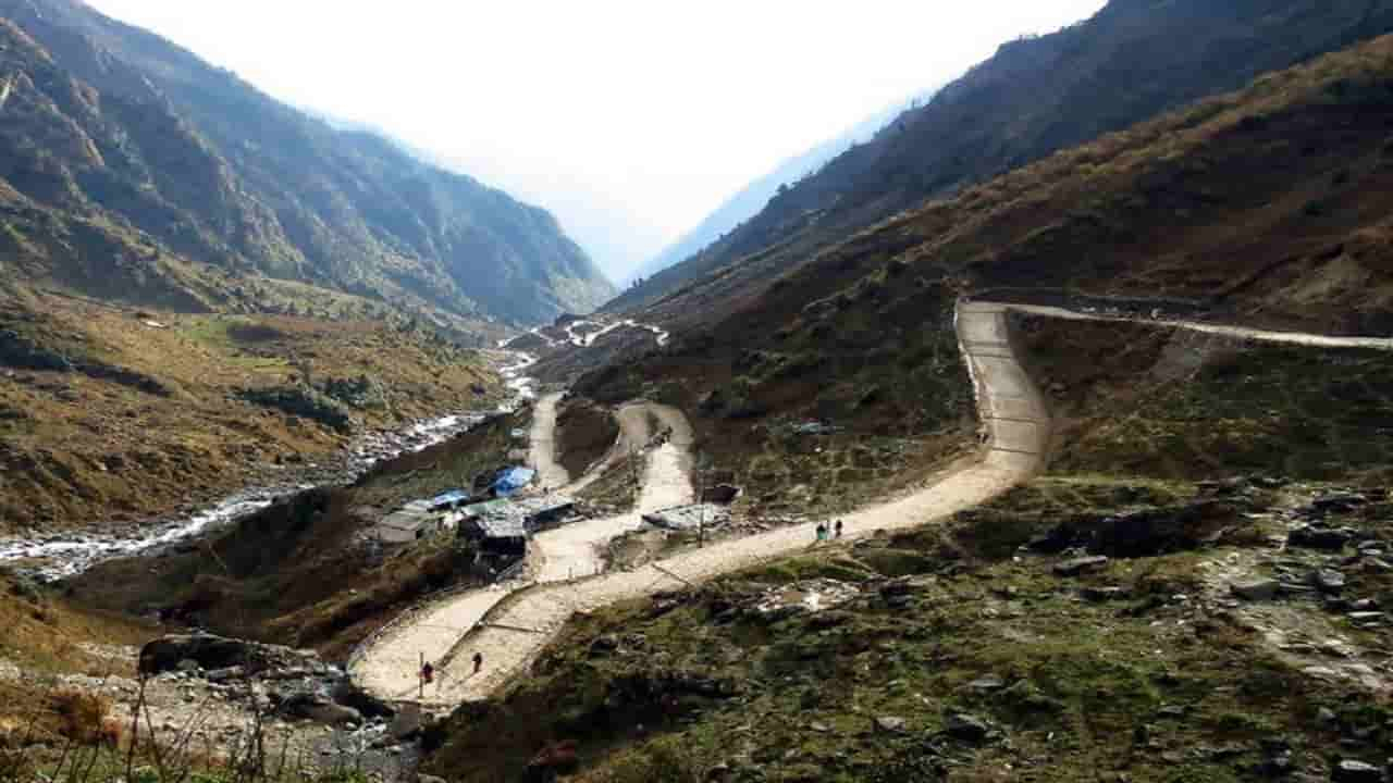
The highways or other arterial road layouts of high mountain regions in the Himalayas mostly follow some river channels. Upper reaches of Rishikesh-Gangotri road follows Ganges and Bhagirathi River (from New Tehri). Similarly Yomunotri (Janki Chatti) can be reached by roads along the banks of Ganges, Bhagirathi and finally Yamuna river channels (from Dharasu). The Rishikesh-Badrinath highway follows first the course of Ganges, and then from Devprayag it follows Alakananda. Road to Kedarnath (Gauri Kund) follows the Ganges, Alakananda and Mandakini (from Rudraprayag) river channels. These four major routes, and the stretch from Tanakpur to Pithoragarh, which in its upper reaches follow various tributaries of Sarda and Kali rivers are part of about 900 km long ‘All Weather Road project’ with estimated cost of 120 billion rupees. A considerable portion of the project is being carried out by the Border Road Organization as those parts would facilitate easy movement of logistics and personnels to the India-China Border posts.
Preference given to laying the road network along the river banks may have a connection to the traditional routes in the mountains. In ancient times, instead of crossing high ridges, locals preferred to follow the river banks. Later, when planning and construction of the metalled roads started, it was much easier for the surveyors to follow the existing trails. Also in the river banks there are already open spaces and less vegetation, hence it is easier to transport raw materials and labour. But with time, widening of those roads and many fold increases in traffic made the hill slopes unstable. The corruption, lack of proper planning and complete disregard of the environmental norms are the key factors directly affecting the lives of people living in the vicinity of the ‘All weather road’ project areas. The initial plan, according to the former chief minister of Uttarakhand, was ensuring maximum width with minimum cutting of hills, widening of the bridges and constructing alternative routes in landslide prone zones. But presently, even an untrained eye would notice rampant cutting of hill slopes in any stretch of the project, though at many places the roads are already quite wide. The reason behind this is, like any other government project, in this project also, actual planning took the back seat and contractors’ interest became more important. Though according to the circular issued by the Supreme Court in 2018, the carriageway width should be of ‘intermediate lane configurations’, i.e. 5.5 meter, presently at many places the highway is much wider than the specified width. The project was supposed to follow the detailed guidelines of ‘National Mission for Sustaining the Himalayan Ecosystem’, which, many experts believe, was obviously flouted in various segments of the project. Moreover, instead of systematic disposal of the debris and muck generated, to cut cost, those are often dumped in the river bed or worse in the agricultural or grazing fields nearby. Artificially deposited debris in the river bed can force a river to change its course, causing destruction. Use of heavy machinery and explosives has caused subsidence of existing metalled roads, disruption and subsequent drying up of natural springs – usually the basic water source in hills. Many villagers have complained to the media that landslides or mudflow from the debris dumped in the slopes have washed away the pathways and trails connecting the villages. Massive deforestation is another source of concern, as in the mountain region, the forest cover plays a major role in slope stability and acts as catchment of nearby rivers. The officially estimated number of trees to be felled for the project is over 56,000, of which about 36,000 have already been cut (according to a report of TOI, Jan, 2021), including slow growing Alpine ones. It is obvious that the actual number would be much higher. The irony of the project name was pointed out by Dr. Pradeep Srivastava of Wadia Institute of Himalayan Geology (autonomous institution under DST) in an interview – “An all-weather road is a misconception. Nowhere is it written that it will withstand landslides and steep slopes.” According to him, as well as various other environmentalists and geologists, instead of such highways accommodating heavier traffic, good roads meeting the local need are more apt for the mountain region. Various petitions to the Green Tribunal have been filed or already heard. Unfortunately the excuse of “Border Security” always gets priority over environmental or social causes. Another example of the callousness of the planning committee is the increased number of landslides in the area. Several media reports and experts’ comments have cited occurrences of landslides in zones which were classified as low-risk zones before the construction started. The landslide prone zones in higher Himalayas, particularly along the existing road network from Rishikesh to Gangotri, Badrinath and on the Pithoragarh section have already been identified in various academic papers and survey reports. Apart from the natural factors like heavy rainfall, higher rate of weathering and geologically weak rock mass, the proximity to the road has been identified as a major characteristic of the high risk zone. The realignment of the roads along a more stable part of the slope, i.e. along the ridges instead of the slope by the river is of course a better option according to many published research papers, but that would involve even greater amounts of deforestation. Kishore Kumar, Chief Scientist at Central Road Research Institute (CRRI), warned in an interview that without a proper understanding of the slope management system, widening the highways is dangerous.
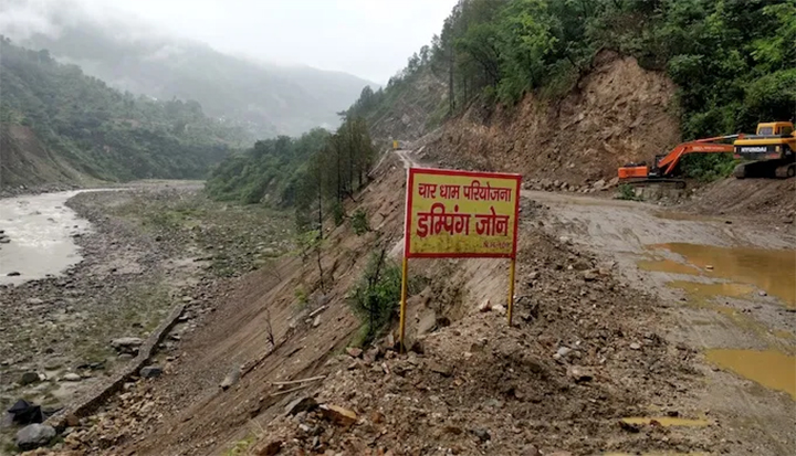
(Image Source https://sandrp.in/2018/10/06/char-dham-highway-project-an-overview/)
Besides the environmental impact, the Char Dham All weather Road project also has negative sociological impact. The loss of agricultural lands due to dumping of debris, loss of connectivity between the villages because of washed away trails and scarcity of safe natural drinking water, rendered many of the villages uninhabitable. Already Uttarakhand has more than one thousand ghost villages, where lack of basic infrastructure has forced the residents to migrate. Since the initiation of the project many more villagers had to relocate to a safer place. Moreover, instead of providing jobs to the locals, the Highway project authority is recruiting migrant laborers thereby contributing nothing to the local economy. Another indirect adverse impact on the local economy has been pointed out by anthropologist and cultural activist Lokesh Ohri. According to him, once completed, this road network is supposed to reduce travel time considerably. Hence the pilgrims and tourists could reach the destination in one day, thereby rendering the local roadside eateries and hotels useless. Presently these establishments are a major source of income in many of the roadside villages. This would not only induce another pulse of exodus, it would also lead to overpopulation in few towns or cities. Already as mentioned, most of the towns of Uttarakhand are reeling under overcrowding and resulting heavy constructions. This would worsen the situation.
Construction of hydro power projects in the region is another controversial issue, which according to the government is essential for ‘development’. According to the Uttarakhand Jal Vidyut Nigam Limited’s (UJVNL) statistics, currently 42 hydro power projects are operating in the state, yielding about 4000 MW of energy. Among them, 19 are run by UJVNL, 4 by public sector companies like NHPC or THDC and 18 by private companies. 82 more projects (UJVN, CPSU and IPP included) are in the development stage. Apparently this kind of green energy production not only brings electricity to the remote villages, the dams control the flow of the rivers thereby checking the flood situation, the construction works related to the project gives livelihood to the locals and finally the settlement for the project employees creates a market for local produce. In reality there is numerous evidence that the construction of hydro power projects or the dams and reservoirs related to the project causes large scale deforestation, disruption and fragmentation of the flow channel, forced relocation of the local people and occasional aggravation of the flood situation. In tectonically active zones like Higher Himalayas (north of MCT), the courses of rivers are often guided by geological depressions or discontinuities like fault planes, along which there are always chances of renewed movement. Also with the changed climate pattern, the rainfall and subsequent debris generation have become unpredictable. Most of the time these geological or environmental evaluations are not done properly or the reports and recommendations are not followed during the planning and construction stage. The zeal of the Uttarakhand government to attain the state’s hydro energy potential of estimated 27,000 MW has been criticized by many academicians, environmentalists and even by some government officials. According to a news report, in 2010, a Controller and Auditor General (CAG) had expressed concern about the adverse effect of about 40 hydro power projects on the biodiversity of the state. In 2013, after the disaster, the Ministry of Forest and Environment enquired about the 600 hydro electric power projects (large and small) in the eco-sensitive zone of Uttarakhand. One of the most affected areas during the 2013 disaster was Bhagirathi basin. According to the Ravi Chopra Committee report (2014), 70% of the Bhagirathi river channel (217 km) is fragmented by hydropower projects. In a review paper (2020) Prof S P Sati has shown that in a stretch of 26 km between Harsil and Gangotri, the number of proposed hydro projects is five. He commented: “Presently the large part of the river section is already inundated and if all the proposed projects become reality, the river will virtually be diverted into tunnels.” Not only in the Bhagirathi Basin, numerous already operating or under construction dams in Alakananda, Mandakini, Yamuna and Kali Basin are also disrupting the flow of all the major rivers and their tributaries in Higher Himalayas, thereby fragmenting the basins and inundating the course of those rivers. Naturally, in the past decade, the hydro power projects of Uttarakhand have come into news for all the wrong reasons.
The first controversial big project was Tehri dam – the biggest Hydro Electric (HydEl) Power project of India with an estimated capacity of 2400 MW but the present yield is only 1000 MW. It has inundated about 44 km stretch of Bhagirathi and 25 km of Bhilangana river valley. About hundred thousand people of the historic Old Tehri town had to be relocated. The idea of building such a huge dam in a geologically unstable zone, and resulting environmental impact on the area, resulted in prolonged agitation by the Anti-Tehri Dam Struggle Committee under the leadership of renowned environment activist Sundarlal Bahuguna. Some government officials claim the dam helped to minimize the 2013 flood damage downstream. According to Bishun Prasad Das (former Chief Engineer with State Water Resource Department, Odisha), it held back flood water, which attained a peak of 7000 cubic meter per second (m3/sec or cumec) and restricted the flow to only 400 cumec. His estimation is, without the dam, about 25,000 cumec flood water of Bhagirathi and Alakananda basin could have reached Rishikesh causing devastation. But the total storage capacity of the dam is only 3540m3. Even if the dam actually saved the Rishikesh town in 2013, it is not that generous to the villages upstream. In a paper published in 2002, Piyoosh Rautela concluded from GIS and remote sensing based studies of the catchment area of the dam, that the reservoir would render a total of about five thousand hectares of agricultural land in upper catchment and reservoir rim area, unfit for cultivation. Since its opening in 2006, the monsoon fed streams in the valley suffer from backwater inundation during high water levels of the reservoir. These are the streams which are the main water source for agriculture in the area. During the low water level, slack sediment deposits in those streams make them unusable. The villages in the upstream side of the dam are witnessing subsidence as the depositional terrace on which those villages are situated, are still adjusting with the changing water level of the reservoir and the pore water pressure of the slopes. The sediment storage capacity of the dam was wrongly calculated, and when the mistake was noticed in 2011, a Catchment Area Treatment plan was initiated on an emergency basis. A study in 2015 by Kumar and Anbalagan had identified about 150 large and small landslides in the area caused due to slope failure, which is vindicated by field observations of S.P Sati in 2020. According to Prof Sati, THDC did not implement a 1991 GSI report, identifying all the vulnerable zones around the reservoir, hence these incidents of landslide and slope failure with changing water level of reservoir could not be avoided.
The flawed planning in the construction stage and resulting indirect impact on the local ecology is not the only drawback of these projects. There is evidence where delayed reaction by the project authority during some calamity directly aggravated the plight of people in the river basin. The controversial Hydro Electric project, situated on the Alakananda River at Srinagar is a good example. Srinagar town is situated at the bank of Alakananda at an altitude of 560m and well connected by road network. Nearby villages are Kaliyasur and Dhari. In ancient times and in the recent past the town and surrounding area has suffered from earthquakes, landslides, cloudburst and floods. The very idea of sanctioning a 330MW power project in such an ecologically disturbed area is controversial. The villagers from the reservoir side and residents of Srinagar town (downstream) were protesting against the project regarding loss of agricultural and farm lands, losing connectivity, inundation of newer areas due to increased reservoir level – as a result of high silt deposition, and against the relocation of Dhari Devi temple to avoid submergence. The power project first suffered obstruction in 1993, when a landslide shattered the proposed project site, followed by flash floods in 2000, 2008, 2009, 2010 and finally in 2013. The powerhouse of the dam was completely inundated during the 2013 flood. The turbines got damaged due to excessive silt deposition and sudden discharge of that huge amount of debris in Alaknanda River channel temporarily changed its course and veered the river towards the town causing severe destruction. This revived the protest and the Srinagar Bachao Sangharsh Committee demanded a proper protection wall along the vulnerable riverside. Ravi Chopra committee noted the impact of 2013 flood was magnified many fold due to improper muck disposal and faulty flood operation of the power project. All in all, this Srinagar HydEl project which is still a threat to Srinagar town and the nearby areas, is producing 330 MW of energy since 2015, at the expense of about 300Ha of submerged land, about 350Ha of affected forest and Rs 4000 crores.
The 400 MW Vishnuprayag Hydro Electric project is another dam built in an extremely fragile geological setting. It is situated in upper stretches of Alaknanda River, close to the tectonically active MCT zone. During the construction of this dam, cracks appeared in the houses and fields of nearby villages along with disruption of local streams. Many of the local activists blame this project for increased devastation downstream after the 2013 flood. Supposedly the project authority did not open the gates when needed. But later when water pressure increased too much, they were forced to open the gates. This sudden gush of water caused flooding of the areas downstream. Also after the disaster, the project was completely buried in mud and boulders. When the flood water receded, the storage space of the dam became a field of dry rubbles. It took over five months to dig out the site and become operational again. These muck and debris they cleared from the site, instead of disposing them following environmental norms, the project authority just dumped the debris on the Alaknanda river bed. As mentioned earlier, the debris when deposited on an already elevated river bed, poses danger of flooding and inundation of the nearby villages.
Following the recommendation of the Ravi Chopra committee after the 2013 disaster, the Supreme Court ordered to stop operation in 27 hydro power projects and stayed clearance of many others. Not only those projects played a role in the 2013 disaster, many of them suffered huge damage. About 20 of the projects were completely destroyed including two mega-projects – the Tapoban Vishugad project (280 MW capacity) on Dhauliganga and Maneri Bhali I & II (304 + 90 MW) on Bhagirathi. As per UJVNL data, reported in TOI, March 2015, the estimated total damage of these 20 projects is about 131.78 crore, and the restoration cost would be about 172.89 crore. During the Chamoli debris flow in 2021, Rishi Ganga project was completely washed away and Tapovan Vishnugad project (still under construction) suffered severe damage. Major allegation against the hydro power project in Uttarakhand is that most of them do not follow the waste disposal directives, reforestation programs and the promise of employment opportunities for the locals. There are instances, as mentioned in the article of South Asia Network on Dams, Rivers and People (Sandrp), October 5, 2014, even after the court order to stay the project or sometimes while awaiting the environmental clearance, MoEF, Central Electricity Authority or Central Water Commission allows the construction or operation of the hydro projects. Rambara HEP, which was completely washed away in 2013, even after the stay order from Supreme Court, is still enlisted under developing projects of CWC. The Sirkari Bhyol HEP on Goriganga river, in Pithoragarh district is another enlisted project in UJVNL site, where construction works started without environment and forest clearance (as per 4th March 2021), nor did the project started cumulative impact assessment of Goriganga and Kaliganga river as recommended by the Expert Body.
Another enlisted project under construction – Lakhwar-Vyasi is supposed to be the biggest dam on Yamuna River, and would become operational soon. This 50 year old project was halted in 1992. But around 2014, construction work resumed based on an old clearance, without any up to date disaster risk study and environmental impact assessment. The indigenous people of Jaunsar-Bawar region reside in one of the 6 villages in the reservoir area – Lohari would be inundated when the reservoir fills to its full capacity. Though initially (in 1972) the authority agreed to offer land in compensation instead of money, according to the Jan 2022 report published in Third Pole, a cabinet meeting in 2021 retracted the offer of land. The village got completely submerged in March 2022. The eviction of the people of Lohari flouts the Scheduled Tribes and Other Traditional Forest Dwellers (Recognition of Forest Rights) Act, 2006, which ensures the right of forest to the tribal people. A report in May 2022 published interviews of the displaced villagers, who were still awaiting compensation.
There are hundreds of media reports about the damaging effects of hydro electric projects, published after the 2013 disaster. In the past few months various reports were published detailing the adverse impacts of Char Dham Road Project but only after the Joshimath disaster happened. Media coverage on the slow and steady destruction of the mountain ecology may play a big role in reevaluation of the damaging projects. But the mainstream media pays attention only when those impacts snowball to some larger disaster, and the visuals of the damage are sensational enough to rouse readers interest and raise TRP.
It is unrealistic to expect any government or private companies or big media to care more about nature and people than their profit. Whenever construction related to the big projects starts, the initial adverse impacts are always felt by the locals. They are aware that construction of highways and concrete buildings that cater to the demand of rich city tourists are damaging the mountains. Building Hydro Electric power plants increase state revenue but severely affect the river networks. They know the traditional village houses were more earthquake resistant than the present day concrete structures. Rain water harvesting using traditional methods was more eco-friendly. Rampant artificial forest fires to create more agricultural lands are destabilizing the slopes. Only a movement by the local communities can force the state government to stop the ongoing destruction and compel it to introduce projects that would help the locals to pursue eco-friendly alternate modes of earning income. For example, in the depositional terraces or landslide prone zones, where the step cultivation can affect the slope stability, fruit orchards would give alternate livelihood without damaging the slopes.
To summarize the discussion, along with the natural calamities common for high mountain regions, unplanned and uncontrolled construction projects in the Himalayas to facilitate a tourist-centric model of development driven by greed for more profit will spell more disaster for the already ecologically over-stressed region. As nothing can be done to stop the havoc caused by the changes in climatic pattern, a radical shift from the current development model is the only way to arrest the rate of destruction in the higher Himalayan regions. The voices of few geologists, environmentalists or activists can be ignored but collective resistance from the local communities is not that easy to suppress.
(The author is a freelance field geologist and an avid traveller)
To read Part I click
To read Part II click
Joshimath is not subsiding but is actually sliding
To read Part III click
Bhatwari, Karanprayag and other Uttarakhand towns awaits the fate of Joshimath