Be it towns like Bhatwari and Karanprayag, small settlements like Dharchula or Gopeshwar, or large tourist hubs like Mussoorie, everywhere over-constructions, lack of drainage management, callous city authorities and ambitious road, ropeway or tunnel projects in the name of infrastructure development, are pushing the delicate ecological balance of this entire region in the state of Uttarakhand towards verge of collapse, writes Meenaskhi Sarkar.
Part III
The Joshimath disaster has brought into focus the issue of land subsidence which has for years been threatening several towns of Uttarakhand, including the town of Bhatwari and Karnaprayag. Bhatwari, a small town of only 1500 residents, situated on Uttarkashi-Gangotri highway in Bhagirathi valley, is awaiting disaster if no measures are taken immediately. As it is neither a tourist spot like Nainital, nor has any religious importance like Joshimath, the subsidence of this town never made headlines. Most of the settlements in Bhatwari are clustered in the narrow gorge of Bhagirathi, near the toe area of a deposition terrace. Geologically it falls inside the MCT zone with highly jointed gneissic and schistose rocks. Loose sediments and giant boulders strewn in the area suggest the presence of palaeo-slide. Various academic papers published on the area noted the presence of scarps (steep slope created by sudden subsidence of land) in the upper part of the town, cracks and subsidence in the roads and fields, tilting of houses and displaced boulders. These features point to intense sinking of the area. Not only this town, the entire stretch between Uttarkashi and Bhatwari on Rishikesh-Gangotri highway has also experienced severe dislocation at many places as a result of slope instability. The 600MW Loharinag-Pala Hydro Power Project was sanctioned (though presently scrapped) even after the Uttarkashi earthquake in 1991 had adversely impacted this area. The Head Race Tunnels and underground powerhouse of the Hydel project were planned or constructed near the unstable slopes of Bhatwari and Kanodia Gad (stream) landslide zone – infamous slide of the 70s, where the debris from the small stream stopped the flow of Bhagirathi for four days. Since 2006, when work for these constructions started, frequent cases of land subsidence were reported from Bhatwari area. Finally in 2009, due to strong protest the work had to be stalled. But by that time, enough damage had already been done to Bhatwari and nearby villages. The area witnessed repeated destruction – due to landslides in 2010, heavy rainfall in 2013 and a cloudburst and resulting destruction in 2014 along with numerous minor landslides – all of which had made the slopes even more vulnerable.
Presently the town (including Uttarkashi to Gangotri stretch) comes under Eco-Sensitive Zone (Declared in Dec 2012). But that does not stop construction activities and use of heavy machineries. The present government’s pet project ‘All Weather Road’ highway is wreaking havoc. According to the experts, the recent increase of landslides in that stretch is the direct effect of the road widening project and related deforestation of the slopes.
When some acquaintances from Bhatwari town or nearby villages were contacted over phone, their response toward the subsidence problem showed an interesting trend. Presently Bhatwari is just another stop en-route to Gangotri, where, during the peak tourist season, people halt for a night in the few hotels available. But when the all weather road project is completed, proximity to Uttarkashi, nice view of Bhagirathi, and accessibility, will help this place to become a tourist hub. Two of the affluent residents of the area – who are planning to build their own lodges or hotels in future – when asked about the situation, completely ruled out the threat. According to them, all the cracks appeared during the disaster of 2013 and presently everything is fine. But the younger generation – mostly trekking guides or porters, and those who have farmlands near the river bed – are aware of the sinking problem. According to them, new cracks appear regularly in the area. They are quite concerned about what would happen when the road near Bhatwari would be widened with heavy machinery and blasting. To quote Manveer Panwar, a 30 year old trekking guide – “No one cares until something big like Joshimath happens”.
Karanprayag is another town that has made media headlines, but only after the Joshimath tragedy. The town situated at the confluence of Pindar and Alaknanda River, has about eight thousand residents. Geologically it is situated on Baijnath Klippe – a thrust zone of highly deformed schist, phyllite and quartzite of Lesser Himalayan Group. Being located at the confluence of two major rivers, the area is prone to landslides and flash floods, as has been reported in various published research work. Apart from being a part of the Char Dham All weather Road project, it is also a part of the Rishikesh-Karanprayag Rail road project – foundation stone of which was laid by Ms. Sonia Gandhi in 2011 during the UPA regime. But work finally started in 2015 under the NDA government. The project, estimated to be completed by 2025, would have 105 km of tunnel.
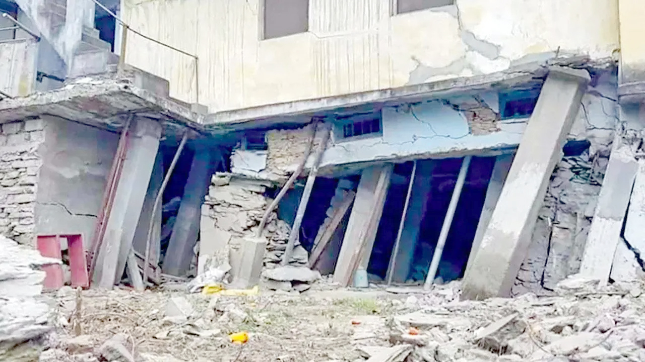
As if to mock these ambitious projects, about 50 houses of Bahuguna Nagar area of the town were first damaged by landslide debris in 2015 and later 150m of Badrinath Highway started showing signs of subsidence. Though the damage of the 2015 landslide was restricted thanks to the initiative of the local municipality, recent widening of the Badrinath highway has aggravated the situation since July 2022. New cracks started appearing in the Upper Bazar area, and damaged houses became completely uninhabitable. Bhauguna Nagar locality is situated on the slopes of Pinder river bank, with Karnaprayag Kankhool road running above it and the marketplace down the slope. Apart from the natural erosion of the slope by the river and due to the road construction, locals are blaming excavation in the marketplace with heavy machinery for the damages. Also, the Karnaprayag Kankhool road does not have proper drainage. Hence, during monsoon, unsystematic flushing of rainwater weakens the foundation of the houses. Some of the affected families, who can afford to rent a new place, had already relocated. Many residents have complained to the media of not receiving any compensation or proper rehabilitation from the government.
The list can go on. Be it small settlements like Dharchula or Gopeshwar, or large tourist hubs like Mussoorie, everywhere over-constructions, lack of drainage management, callous city authorities and ambitious road, ropeway or tunnel projects in the name of infrastructure development, are pushing the delicate ecological balance of the region towards verge of collapse. Mr. Ravi Chopra, a research scientist and former chairman of Char Dham Pariyojana Committee, in an interview published in Frontline, has pointed out how the government’s idea of development – focused more on industrialization, not on actual development – is playing a major role. Mr. Ravi Chopra is a leading figure in Uttarakhand associated with various environment, disaster mitigation and development projects. He resigned from chairmanship of Char Dham Pariyojana, when his recommendations were ignored by the government. He was also the head of the committee investigating the impact of Hydel projects after the 2013 disaster in Uttarakhand. Not only Mr. Chopra, Piyush Rautela, Executive Director of Uttarakhand State Disaster Management Authority, S. P. Sati, Professor of Geology, HNB university – a central University of Uttarakhand, Dr. Navin Juyal, retired research scientist of Physical Research Laboratory, Ahmedabad (Central Government Institute) and various other academicians, have been discussing these issues, publishing papers, and giving interviews to the media for the past decades. But their articles or news reports could not stop the destruction drive of the state or central government.
(to be continued)
Cover image: The collapsed portion of a house at Bahuguna Nagar in Karnaprayag in January 2023. Pic/PTI
( The author is a freelance field geologist and avid traveller.)
To read Part I click
Fragile geomorphology, and unplanned uncontrolled infrastructure development are key to Uttarakhand disaster
To read Part II click