Every report or article published in last 50 years – from Mishra Commission report in 1976 to Ravi Chopra’s recent comments in 2023, clearly recommended against the use of heavy machinery for large scale projects in the area, and asked to take special care to maintain slope stability by forestation. Yet, the ‘development’ went on. The government did not intervene to stop mushrooming of hotels and buildings in the area. Neither the state government, nor the private companies carried out any detailed geological and geotechnical survey of the slope before constructing the big projects writes Meenakshi Sarkar in the aftermath of the Joshimath disaster.
Part II
Some of the villages around Joshimath that suffered effects of sliding or flash floods in recent years are Ravigram, Chaien, Raini, Hailang, Pandukeshwar, Lambagar and Govindghat. Joshimath town (1875m) is located on the northern slope of a narrow gorge at the confluence of Alaknanda and Dhauliganga rivers. One of the major Himalayan fault zones, MCT, passes through the area. The mountain slopes of Joshimath block lie within the MCT zone and have very fragile rocks as a basement. These rocks are highly deformed and sheared gneiss and schists. Moreover, the town itself is built on a relict landslide debris, first mentioned in published works of Heim & Gansser in 1939. Historically, it was the capital of the Katyuri dynasty. According to the historian Shivprasad Debral, around a thousand years ago, the capital was moved from Joshimath after a devastating landslide. In 1961, it was a small remote religious settlement of about six thousand people. Later, when adventure sports became popular in India, a large number of trekking enthusiasts started to visit the town. Many lodges and hotels were built to cater for the tourists. According to the 2011 census, the population of Joshimath town was about seventeen thousand and it is estimated to be over twenty two thousand by 2022. Like Nainital, the problem of Joshimath town is mushrooming of the new constructions without proper urban planning. Lack of adequate drainage and poor groundwater management makes the situation worse. The pressure of groundwater counteracts the pressure of increased overburden on the loose landslide relics and over-extraction of groundwater have contributed to the destabilization of the slope. Also the toe of the slope is continuously undercut by the Alaknanda River, further affecting the slope stability.
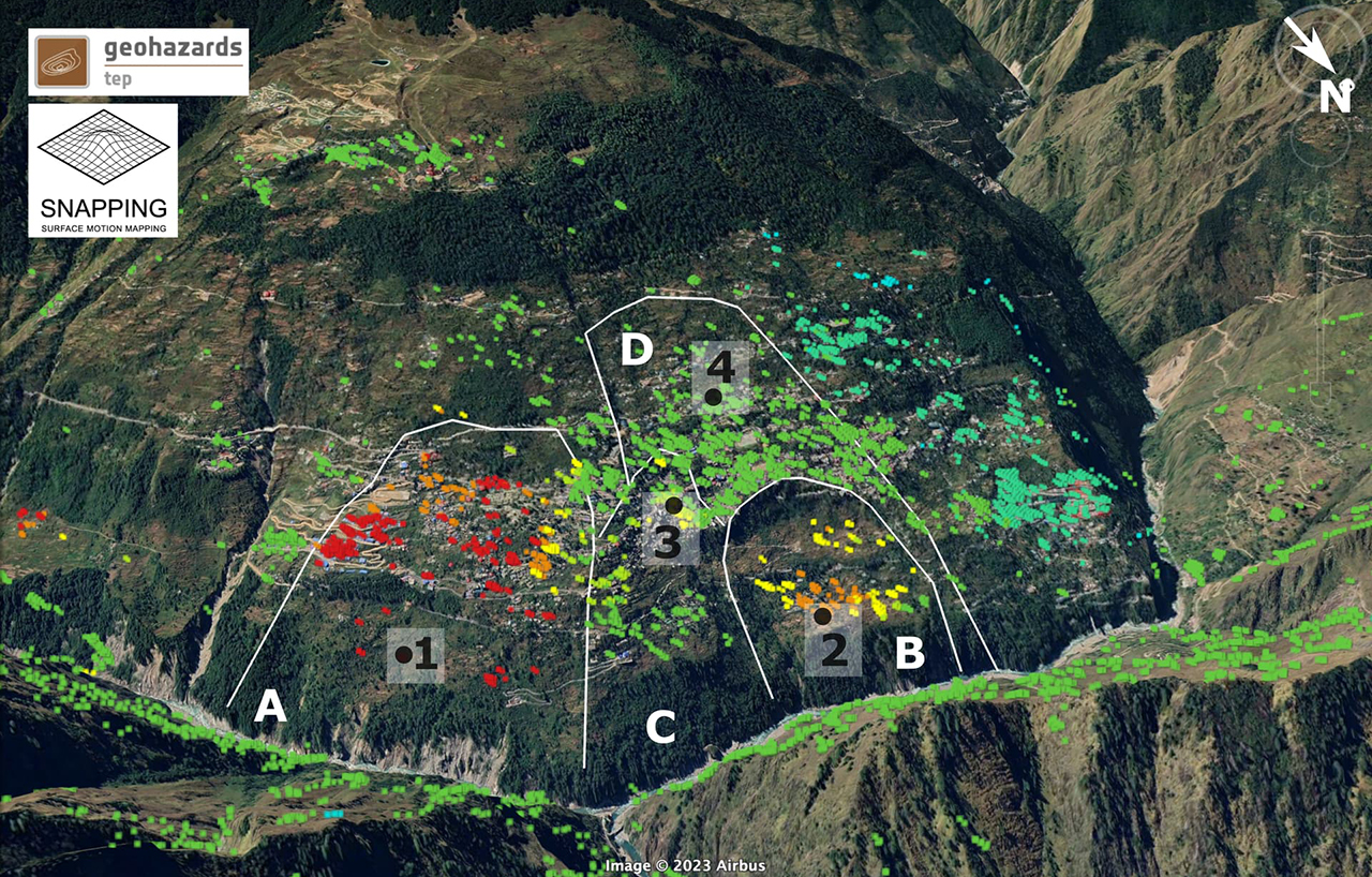
3-Dimensional view of the Joshimath slope with the SNAPPING Full Resolution PSI results overlaid (background Google Earth). The location of the active units (A, B, C, D) are delimited by white lines.
A recent analysis of satellite radar images shows the surface motion for a broad region of Joshimath from Jan 2018 to Dec 2022. The results of this analysis for Joshimath area are available in the public domain. From the pictures, deformation signals are clearly visible from Joshimath and its opposite slope – where Chaien village (population 500) is located. Chaien is the village where first incidents of sliding and resultant cracks in the houses and fields were reported in 2007. The images show that the entire north facing slope of Alaknanda River can be divided into four landslide blocks. Among them, two blocks of Joshimath slope have been continuously moving downhill for the last four years. Most actively deformed part lies on the eastern part of the slope of Dhauliganga – mostly around the NTPC Township and few hotels. Here, the blocks are moving downslope at a speed of about 10 cm/year. On the southeastern side of the same slope at the depth of 900 m lies the disputed tunnel (discussed later) for Tapovan Vishnugad Hydro power project. Another active zone on the western flank of the slope is moving about 3 cm every year. Interestingly, this area is close to a new bypass to Badrinath that is being constructed near Helang (or Hailang) as part of the Char Dham All Weather Road Project. Rest of the slope – most of the upper part and the part between the two active blocks – registered very small displacement until the end of 2021. But in early 2021, the area between the active blocks also started to move downhill at a quickened pace. According to geologist Dave Petley these new satellite data confirms that Joshimath is not subsiding but is actually sliding, which means that it is moving downhill almost parallel to the slope by the pull of gravity. Not all blocks are moving at the same speed. When two blocks move at different speeds, cracks appear at the block margin where the deformation is maximum. The now retracted ISRO report published in Jan 2023 stated 8.9 cm sinking between April to November 2022 and 5.4 cm sinking during 27th Dec 2022 to 8th Jan 2023. According to Dave Petley, the amount of movement reported by ISRO is an understatement when compared to the actual damage observed in Joshimath.
The stretch of Alaknanda valley with Dhauliganga and Rishi Ganga as tributaries is not new to destruction. Some notable disasters that caused loss of life and property in the area – flash floods, cloud bursts, landslides and sinking – are presented below along with concerns raised by scientists about the risk of hazards. These disasters clearly show the effects of ‘development projects’ in an unstable area located on the northern side of the major fault zone MCT and an area that is particularly susceptible to a changing climate. The first recorded major incident in the area happened in July 1970. A cloud burst induced flood in Alaknanda River carried about 15.9 billion metric ton of sediment within a day. The settlements in Pipalkoti and Helang were completely washed away. At that time, some experts and most of the locals argued that large scale deforestation was the main reason behind the flood. Recent studies have established that the flood was a direct effect of deforestation. This devastating flood made the people aware about the ecological balance in the area, which finally led to the famous Chipko Movement of 1973, under the leadership of Sundarlal Bahuguna. The small village Raini, 20 km from Joshimath, (and later the victim of Chamoli Debris flow of 2021), protested against a government backed logging project and stopped felling of nearly 2000 trees. The women of the village, led by Gaura devi forced the project to stop and later a 10-year ban was imposed by the government on commercial logging in the area.
After the Indo-China War of 1962, the government initiated two major border road projects in the area, one from Dhauliganga to Maleri, and the other from Alaknanda Valley to Mana. In the early 70s, cracks started to appear on the hill slopes of the area because of floods and blasting related to road construction. To identify the unstable areas on the hill slope, the Mishra Commission was formed. The commission recommended a ban on new construction – both residential and big projects in the area, and a ban on heavy machinery. It said “Vibrations produced by blasting and heavy traffic will also lead to disequilibrium in natural factors”. Also, the commission suggested that large boulders in the area should not be disturbed. It also suggested planned forestation on “bare peaks and the slopes, military camping ground, Marwari, Belt along Alaknanda, Vishnuprayag and Dhauli Ganga, and Area Khon” instead of agriculture on the slopes.
The residents of Joshimath did not welcome the Mishra commission report at first, as the small settlement had just started to flourish as a tourist spot. The government failed to implement the commission’s recommendations, and on the slope of Joshimath major construction projects like army camp, ITBP camp, widening of highway went ahead. By late 90s, when already too many hotels and lodges created an acute drainage problem, some of the town residents realized what danger was looming in their future. Around the same time, NTPC came up with the proposed 520 MW Tapovan Vishnugad Hydel Power Plant on Dhauliganga river. The estimated cost of the project was 2978 crore. In 2003, the residents, including activist Atul Sati, urged the government to stop the construction of tunnels related to NTPC projects. In 2004 Joshimath Bachao Sangharsh Samity was formed. Despite the protest of the locals, the Hydel project was inaugurated in 2006, but NTPC promised not to use explosives while tunneling on the Joshimath side.
In 2007, an incident of sliding related to another tunnel construction was reported from Chaien village. That tunnel was part of a 400 MW Vishnuprayag Hydro Power project of the JP group. At the beginning of the project, in the late 90s, on behalf of the JP group, the villagers were promised of a better life, in terms of jobs, better school, electricity and roads. But by 2007, houses and fields of 22 families were damaged. People started to relocate to safer places at their own cost. There was no compensation from the JP group. The families received from the government a small piece of land without papers and a pittance of 3 lakh 60 thousand rupees to build a house. Since then, there have been incidents of leakage from the power shaft of the power project and flooding of roads. So far, the JP group has done nothing to help the situation.
Around the same time, cracks started to appear in Tapoban village due to the blasting operations for the NTPC project. By the end of Dec 2009, the tunnel boring machine introduced in Joshimath slopes got stuck, and punctured an aquifer one kilometer below the surface, near Shelong village. This led to a huge discharge of groundwater – an estimated amount of 700 liters per second or a daily discharge of about 60-70 million liters of water. This kind of sudden discharge in an area, which is sitting on unconsolidated debris, can cause havoc. As mentioned earlier, the balance between the pore water pressure and the weight of sediments is very important for the right amount of “stickiness” between soil particles that keeps the slopes stable. Sudden discharge of water affects the stability to a great extent. In an article in Current Science in 2010, Piyoosh Rautela, the Executive Director at Uttarakhand State Disaster Management Authority, expressed concern about how the government has given clearance for multiple hydroelectric projects in the area, even after the vulnerabilities of the slopes around Joshimath and Tapoban became clear. He also noted that instead of the Geological Survey of India, NTPC hired a private company to do the geological survey. And that company simply ignored the earlier geological investigations of the area and did not bother to calculate the amount and nature of overburden (load of the rock mass) along the tunnel alignment. When Mr. Rautela, who is a part of the state authority of Uttarakhand, expresses his disappointment in an academic article, it demonstrates how some sections of the government with a ‘growth frenzy’ ignored the warnings from the experts, who studied the region for many decades. Rautela concludes his article with a warning “It is too early to foresee the full long-term implications of this event but these are sure to be serious. This is a clear case of negligence on the part of the agency undertaking the exploration in this sensitive zone. It calls for stringent compliance of the preliminary investigations together with harsh punitive measures for the ones who fail to comply.”
During the disaster of 16-17 June 2013, the entire Alaknanda valley witnessed severe destruction. A huge amount of glacial debris including large boulders were dislodged and carried downstream due to sudden heavy rainfall, finally bringing the disaster to Kedarnath region. The reason behind the loss of life and property in that area was mainly tourism related constructions that developed in the last couple of decades on the flood plain of river Mandakini.
But in Dhauliganga – Alaknanda area there was no evidence of such huge sedimentary deposits caused by recent landslides. There was some evidence of intermittent natural damming along the streams of Rishiganga and these two rivers. Also, the glacial deposits are located far up in the mountain, that too on the rain shadow zone (on the other side of the ridge that is not affected by the rain and drainage to the river). But geologists Navin Juyal and Y. P. Sundriyal wrote in Current Science that the sediment level in Alaknanda valley exceeded the flood sediments of 1970 by 15m in Bhenswara (near Devprayag – further downstream of the river). They concluded that those sediments were “locally generated by unnatural processes” from the newly constructed road network and the hydropower projects. Many villages of Joshimath block, namely Aruri-Paturi, Padagaasi, Lambagar started sinking in the aftermath. Along with Lambagar, Pandukeshwar and Govindghat almost 10 villages of the area with 500 families were marked disaster affected.
In an article published in The Hindu (Dec 2013), the residents of the affected villages of Joshimath blocks directly blamed the Vishnuprayag project of JP Group for flouting environmental regulations and dumping debris on the riverbed even after the disaster. After the flood, the riverbed elevation rose by 8 m. According to an eyewitness from Pandukeshwar village, the project was emptying lakhs of metric tons of muck in the already elevated riverbed. The government chose not to intervene. Gross negligence on part of the government is business as usual in these remote villages in Uttarakhand. The authorities did not provide any rehabilitation for the flood-affected villagers. They did not take any measures to stop the sinking, nor did they clean up the riverbed.
Similar incidents kept happening. In an article published in 2015, three advisors of L&T and NTPC reported cases of large-scale water ingress into the tunnels related to Tapovan Vishnugad Hydro Power Project in 2009 and 2012. The water pressure opened up fissures in the wall rock and widened the existing fractures. In 2019, a cloud burst caused flash floods in Govindghat that washed away 30 m stretch of Badrinath highway and buried 40 vehicles. Electricity and communication were severely disrupted and thousands of tourists were stranded in various locations of the area.
Next large-scale disaster was Chamoli Debris flow that took place on February 7th, 2021. It flattened around 20 hectares of forest land, damaged two Hydel Power Projects in Rishiganga-Dhauliganga area and cost nearly 200 lives. A huge chunk of ice and rock that broke off from the Raunti peak, after about a two kilometer vertical drop, smashed against the slope below. This huge impact initiated a landslide and a dust cloud creating enormous amounts of debris. After moving down the slope along Raunti Gad, the ice melted due to frictional heat, and created a massive flow of water and sediments along the Rishiganga channel. The debris flow had reportedly carried about 27 million cubic meters of materials that was deposited downstream, including boulders as big as 20 m in diameter. According to some eyewitnesses from Raini village on the bank of Rishiganga, within 15 minutes of hearing a large blasting sound (possibly the sound of smashing of the chunk to valley floor), the debris flow swept away the bridges and the structures of Rishiganga hydel project near the village. By that time, it had gained a speed of 90 km/h. The flow continued downstream to Dhauliganga valley, destroyed the structures of Tapovan Vishnugad Hydel power project of NTPC and finally deposited a major portion of the sediment load below the slopes of Joshimath. After the disaster, in a letter to the Prime Minister, a group of 30 eminent scientists from all over India, requested a thorough review in the policy of building dams in higher Himalayan reaches.
According to the activist Atul Sati, first evidence of cracks in Joshimath town started appearing in November 2021. Fourteen families were affected and had to relocate, again without any help or aid from the authorities. By then, NTPC was trying to retrieve their tunnel boring machine by cutting another bypass channel that involved blasting operations at the southeastern slope below Joshimath town. At the same time, at the base of western slope, 20km long Halong-Marwari bypass construction, a part of Char Dham All Weather Road project, was started, and that involved slope cutting with excavator and occasional blasting.
Alarmed by the appearances of cracks in houses, roads and fields; sudden gushing of water from the cracks, and disappearance of streams around Joshimath and other villages, the residents of the town requested Dr. S. P Sati, Dr. Navin Juyal and Prof Shubhra Sharma to carry out an independent survey of the area. Dr. Juyal was one of the members of SC appointed Char-Dham High Powered committee. In their report, published in various newspapers in June 2022, they clearly stated “As an immediate measure, there should not be any excavation activities, particularly of the precariously balanced crystalline boulders.” They recommended an integrated study of the area by a team of geologists, glaciologists, environmentalists, and botanists. Since then, both Dr. Sati and Dr. Juyal in various interviews have expressed concerns particularly about the water loss in NTPC tunnel, and the course of the Halong-Marwari bypass, which is mostly built on the unconsolidated landslide debris.
Finally, by the end of 2022, Joshimath Problem reached its climax when many houses started tilting, and showed large cracks with water sipping through them. By the first week of January 2023, nearly 600 houses of Joshimath town were severely damaged. Government finally ordered to stop work temporarily in both the Hydel project and Halong-Marwari bypass project. After a large part of Joshimath became uninhabitable, this order was too little, too late. Eighteen years after the first memorandum was submitted by Joshimath residents about the problem, years of continuous protests, rallies, requests by the residents and warnings from various scientists and environmentalists, many committees are now formed and appeals are filed in courts for investigating the cause of sliding – but there is nothing left to be done for Joshimath.
In the aftermath of the Joshimath disaster, an interview with Ravi Chopra, a research scientist and former chairman of Char Dham Pariyojana Committee, was published in Frontline. When asked about the possible way forward, he said “The first thing is to carry out surveys on unsafe areas.” – the same goal for which the Mishra Commission was formed in 1976. In the interview, Mr. Chopra suggested the following – sustainable eco-friendly development in the mountain region, proper planning of any development project, involving knowledgeable scientists and assessing the effects of development on the ecology of the area. Both in Nainital and Joshimath, each report or article published in last 50 years – from Mishra Commission report in 1976 to Ravi Chopra’s comments in 2023, and clearly recommended against the use of heavy machinery for large scale projects in the area, and asked to take special care to maintain slope stability by forestation. Yet, the ‘development’ went on. The government did not intervene to stop mushrooming of hotels and buildings in the area. Neither the state government, nor the private companies carried out any detailed geological and geotechnical survey of the slope before constructing the big projects.
(To be continued)
(The author is a freelance field geologist and avid traveller.)
To read Part I click
Fragile geomorphology, and unplanned uncontrolled infrastructure development are key to Uttarakhand disaster